It is clear from Antonio de la Calancha’s account that there are, or were, three marked stones close to Calango. All three were honoured in the district. “The people greatly valued these three rocks, and built shelters of branches over them, out of respect”.
The community had a consistent story of how the marks had been made by a mythical Christian preacher “…a tall bearded white man…” who had travelled through the area. This played to the missionaries’ desire for an earlier presence which gave continuity to their particular New World myth that god had chosen the Spanish to do his work on the continent.
It seems that the locals had learnt to put a catholic front on their own rituals, as we can see described in the Huarochiri manuscript. The later partial destruction of the stone by Duarte reflects the harder line against idolatry introduced by Francisco de Avila working with the Jesuits, which was to continue for much of the seventeenth century.
In any case, we have two witnesses describing a site “…a stone in the valley above…” where the mysterious visitor rested for the night, according to Juan Vasquez.
The Padre, Fray Raymundo Astado according to a marginal marking in Antonio de la Calancha’s 1638 online text, gives us more detail. The indians took him “…twelve or fourteen blocks from town to a plain in the valley above, where they sow coca. Here, they showed me on a flat rock the appearance of a large body that is wrapped in a shroud, for it has its feet together, and I saw the heels, the calves and the thighs, the elbows neck and head”.
“The print of the other foot is on another great rock by a bend in the river, where he was preaching to the crowds…”, according to Juan Vasquez, and the Padre tells us “he left his other footprint across the river, as he was leaving for faraway places…”
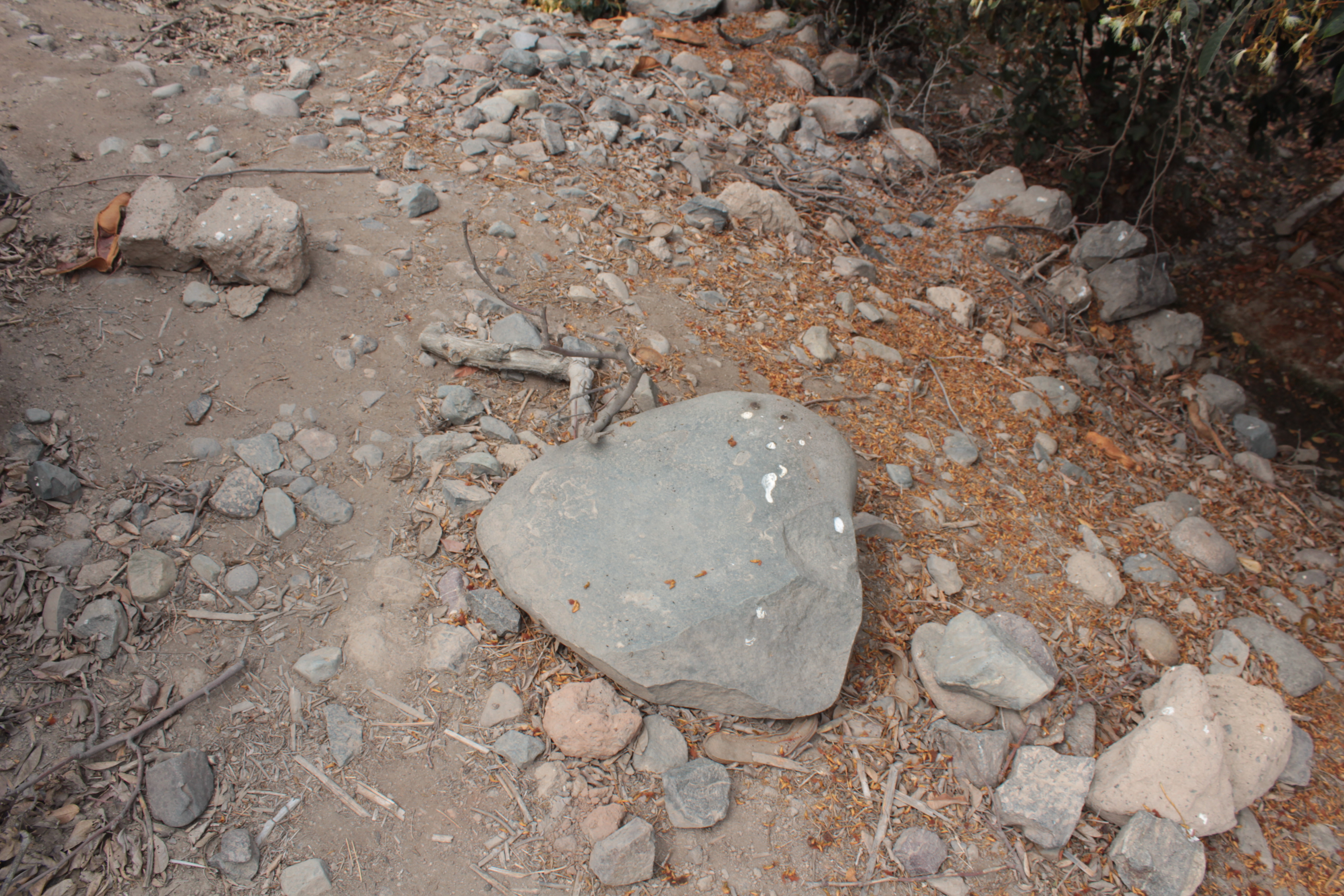
It may be that the stones have long since been destroyed, by farmers clearing their land or the cracks of heat stress when the fields are burnt before a new planting. However the Padre describes them as “…great rocks…” and we have plenty of detail to help find them. The first is a “flat rock”, in a plain in the valley, a level area for cultivation. It is twelve blocks to fourteen blocks from the city.
Antonio de Calancha’s original writing uses archaic Castellano, the language of Castile, where the Pizarros and the Conquistadors came from. The word he uses is quadra, which is still used today, as cuadra, for a block of city buildings, the distance between two parallel streets in the planned grid of a city centre.
In Buenos Aires, Argentina, a city block, a cuadra, is 129 metres, by Spanish Imperial decree. A cuadra in Chile is 125 metres. In Colombia, a cuadra is a unit of area, 80 x 80 metres, Another writer says 64 x 64 metres. Others are more cautious. A cuadra is a measure of length between 100 and 150 metres. A cuadra is 100 varas, and a vara can vary.
A local interpretation for a cuadra in Spanish Peru would be a unit of length equivalent to a block of sixteenth century Lima. The street layout of the original walled city of Lima, established close to the sea to manage the shipping of stolen gold and silver back to Spain via Panama, has not changed to the present day. It is easy enough to see the grid pattern walking through the central Plaza de Armas with the Cathedral and Archbishop’s Palace on one side, adjacent to the modern Presidential Palace on the site of Pizarro’s original residence. The blocks today, as on maps of the original Spanish city, are a little more than 100 metres long.
Some of the decaying houses here have been owned by the same family for hundreds of years, though many are now rented out to hundreds of tenant families living in crumbling wood and plaster shells; every year, fires destroy a few more. Most are being left to collapse. But cuadra was also a unit of length, used throughout the Spanish new world, and still in use in places today.
Antonio de la Calancha, apparently quoting Fray Antonio, gives us some other measurements – the stone is doce pies largo, twelve feet long, and the mark St Thomas’ footprint is catorce [quatorze] puntos long. Furthermore, Calango is three leguas from Mala, ten leguas from Pachacamac and fifteen leguas from Lima.
Antonio de Calancha measured the Calango stone in varas, dos varas y cuarta higher at the head, seys varas y cuarta largo, six and a quarter varas long, and four and a half varas wide. A photograph by Cuban adventurer Nuñez Jimenez of a companion standing next to the stone suggests the width is twice her height, perhaps 3.5 metres, if the person is of average Cuban height – rather taller than average Peruvian height. And now we can fly over via Google Earth and measure the width as 3.6 metres and the length as 5 metres. This is fairly consistent with a vara being about 0.8 metres. This would put Fray Antonio’s twelve pies long, with a pie of 40 cm, whereas a pie was about a modern foot, or 29 cm.
De la Calancha reckons St Thomas’ footprint at 12 puntos, but a Spanish punto was less than 0.2 mm. Exactly what part of the markings the divines considered a footprint is debatable, their sketches of the stone are little help, but an adult human footprint would be about 3o cm or 140 puntos. Looking back at the original copy, we see that the Padre has “catorce puntos” whereas de la Calancha says “doce putos”.
All this tells us that the measurements provided by these sources, are accurate to a little less than 30%.
The distances in leagues match 116 km from Lima to Calango, 20 km from Mala to Calango, 84 km from Pachacamac to Calango at about 8 kilometres to a league, a legua. But other sources put a Spanish (Castillian) legua at a little more than 4 km, orthree miles, or the distance an adult would walk in an hour. There was, at this time, no consistent method of measuring an hour, other than by observing the sun.
Much of the world used local units in the sixteenth and seventeenth centuries. A punto in Peru presumably was two to three centimetres, to make St Thomas´footprint sensible. Otherwise, we find that the Saint had feet the size of one of these letters on the page (which are printed in 11 point, points today being a universal measure of font size). These measurements suggest we can trust a de la Calancha vara, but should be more cautious about Padre Antonio’s quadras.
In any case we are looking for a flat stone several metres across, in a plain by the river twelve to fourteen cuadras, between 800 and 1800 metres, up the valley. The most likely area will be between 1500 and 1750 metres upriver, using a 125 metre cuadra based on the historic streets of central Lima.
There is, here, a broad area of cultivated land on the north bank of the river, almost 500 metres broad, divided into 40 fields and with tracks running through.
On Google Earth, the fields are laid out in grids between the road and the river. Paths run down at intervals from the road to the river, and two other routes run parallel to the river. I identify 15 objects, dark, round, which could be large boulders, in the fields between 1 and two kilometres out of town.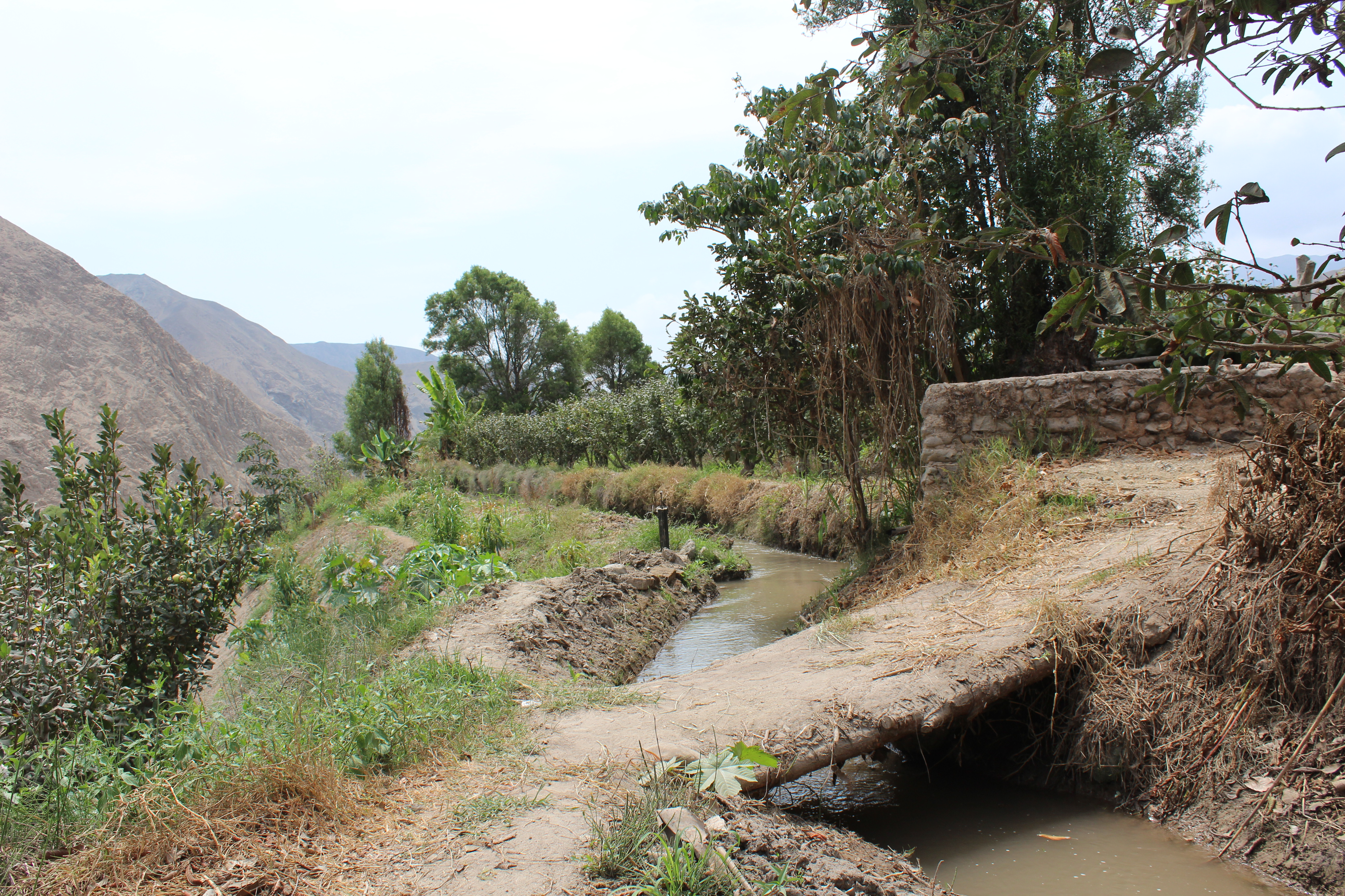
This will be my first walk on rough ground since I was able to put aside my crutches, and I was hoping to find a bicycle to hire to help me get around. I had found a promising shop front painted bright red “Shimano brakes”, “bike repairs”, but it had been shut. In front of the neighbouring shop, the boy cleaning a carburettor told me, “go up the road and left, he is in front of the sound system.”
I was looking for a shop selling loudspeakers, but by the market where the mototaxis queued for passengers, there was a tent offering eye tests, with a loudspeaker blasting out reggaethon mingled with eye care advice, and across the alley was a tiny tin shack just barely containing four card players seated round a table. Hung from the walls and ceiling were various frames, wheels, tires and cables, none of them new, and in the roadway in front of the shop a round sweaty man in a spiderman t-shirt was adjusting the gears on a pink child’s bike.
No, they had no bikes to hire.”It costs too much for here. I am lucky to get five soles for doing repair.” the man told me matter-of-factly.
So. I was going to explore the fields of Calango on foot, searching for a broad flat stone several metres wide. A difficult thing to miss, surely.
I stop in the main square with its church on one side and Municipal offices on the other, a small neat park with trees, benches and triangles of grass in the centre. I buy water and ask the shopkeeper if there is path down to the river. She consults her friend.
“There is one here but it is shut today, it is being repaired. It will be open on Sunday for the restaurant. The other,” she points downstream, “there is a way but is is a little complicated.”
Heading east out of town, the houses continue for four blocks, and then the gravel road curves past plots of land marked off for building, flattened earth and small boulders, some small areas of barren land with vines. As the village road re-joins the main road a path between two wall of stone and mud cuts down towards the river. It soon comes to an end looking out over lower fields that border the river. This is the upper canal to irrigate the fields, a ditch of fast flowing water on a raised embankment. A narrow path runs along the top of the embankment, with the stream on the left and a drop down to fields of miniature apple trees arranged in geometric lines. The path is on fresh dry soil and piled lumps of turf, the product of the annual cleaning where silt has been scooped out of the canal, the riego, and piled onto the embankment.
Here the water belongs to the community, who all take part in the annual repairs. But at the same time these channels are watering private fields and I had no desire to come across an angry campesino and his dogs. I call to two women picking apples in the field “Is it good for me to walk here? Is it private?” They waved back “it is not private, go ahead, take a walk!” Outside of Lima I feel I can walk freely, whereas the city is all security fences, video cameras, a prison. With the Lima inhabitants on the inside.
This water is taken from higher up stream in long, almost horizontal channels that can irrigate land on either side of the river further downstream. These channels can run for tens of kilometres, and be a hundred metres above the water level.
The embankment narrows until I am walking an uneven path over turves above a drop on either side. To the left I look along the breaks between the rows of trees for boulders, but I can only see for a short distance on the rising ground. To the right, I am looking down on a field several metres below. Periodically, water gurgles from the canal under the footpath and down into the lower field and along channels scraped in the topsoil parallel to every row, delivering water to the roots of each apple tree. The apple trees stand less than two metres high, their branches pruned close to the trunk, and they are in rows two metres apart. Any giant stones in the fields below would be easily visible. There are occasional small boulders of the same water-smoothed hard dark rock, often built into the walls or embankments. In the stream bed too, several hundred metres away, I can see giant rocks with the conformation of the Chincheros stones, gradually sloping on the upstream side and then dropping abruptly downstream, like wedges of grey cheese. But there are no boulders visible of significant size in the fields.
I check my hand-drawn map from google Earth. The large dark objects I had identified, at the side of a pathway or in the centre of a field, appeared to be mostly trees.
The canal finally crosses with another path from the main road, and once again I am walking between mud walls with a view over fields on either side. To the left are two mounds of earth and pebbles, one with a scarecrow, a rough effigy of a man hanging between two poles, swinging in the breeze to scare away the pigeons. I reach a second canal which I follow for a short way, crossing a bridge made of a great slab of granite to look down on fields edging the river, fringed with tall canes. There is no sign here of the dark mark on Google Earth, the possible boulder, that I had marked on the map. Only a broad man, bare-headed, contemplating his field, unprepared and unseeded.
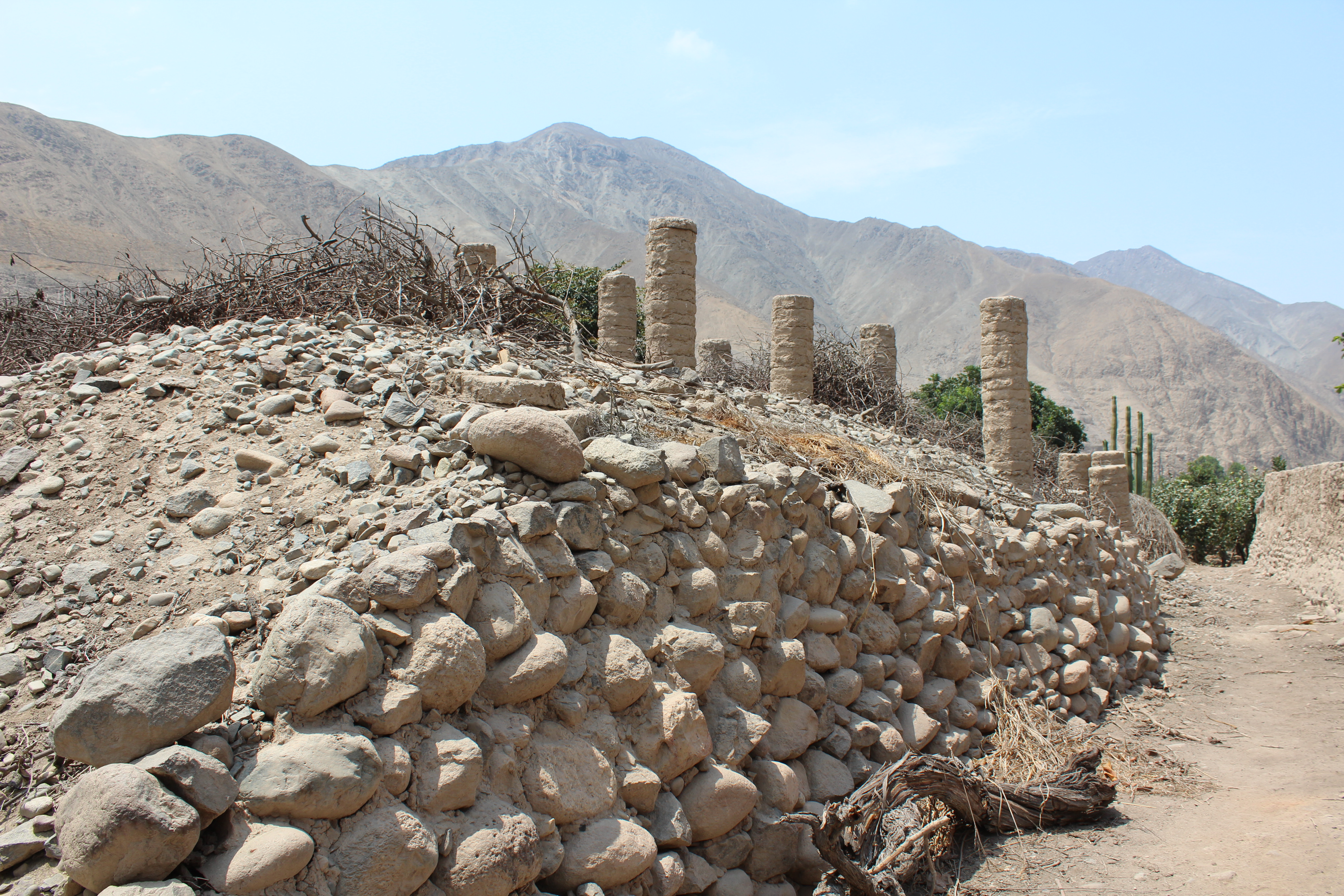
Returning to the path it leads me to a third canal which flows past a mound decorated with round pillars. The mound is more than ten metres wide and is banked up with a wall up to two metres high. Its summit is more than four metres above the field, built up of small loose stones. The adobe pillars would have been built to support vines, but there is nothing alive here, only some San Pedro cactus on the southern edge. For a pile of stones from clearing the fields, it seems impressively large.
The path leads back to the main road from where I have a broad view of the fields below. I mark off the empty fields on my hand drawn map as I walk. Rounding the bend of the road, new house plots are being marked out with flimsy woven reed partitions or flattened cardboard. Fragment of mussel and abalone shells from ancient middens and burials dribble down the hillside from the disturbed ground.
Towards the end of the. plain of farmland, as the river approaches the road and makes a sharp bend, a rocky footpath leads down through rocky fields, but these are rough hewn tumbled rocks, not water worn. A glance at the hillside above shows a fan of boulders descending from the mountain. The path peters out by another irrigation canal.
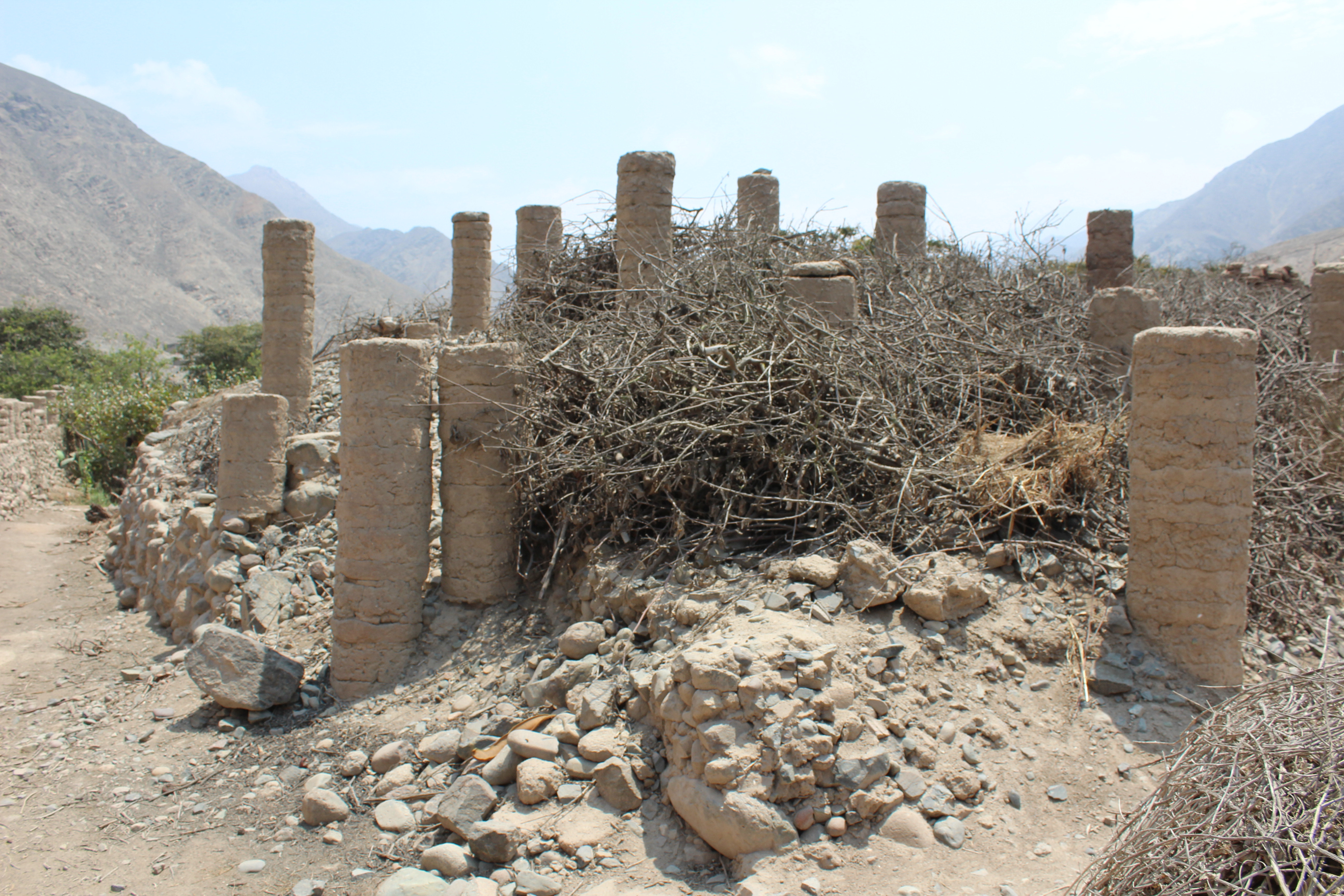
I return via the road, which runs several metres above the valley, giving me a clearer view down onto the fields. From here, the only visible features are the great mound of discarded pebbles ten metres wide by fifteen metres long, and two similar mounds. I walk down a narrow path of the road to get a closer look. One with a scarecrow seems clearly to be a pile of stones, individual pebbles being visible. The second seems smoother, whiter, and less evenly shaped. It even has a wall of adobe climbing up it, dividing the fields. Would you build an adobe wall atop a shifting pile of pebbles, or make your trash pile spreading across two neighbouring fields? At the least, it is worth further investigation.