In northern Chile, stretching six hundred miles down the coast of South America and expanding into Bolivia, Peru and Argentina, lies the Atacama Desert. This barren landscape consists of a coastal plain of sand and stone, with low hills rising inland, up and up to the spine of the Andes, to a plateau with expansive salt flats, out of which towering volcanoes reach 5000 metres into the sky.
Several vast prehistoric lakes were formed in the Bolivian and Chilean highlands by the uplift of the Andes. The rocks here, at 3600 metres above sea level, have fossils of corals and shells. The lakes remain, but they have no exit to the sea. They have islands formed by volcanic cones. Titicaca, the world’s highest navigable lake, drains, in the rainy season, into the neighbouring Bolivian Poopo and Uru Uru, which in turn feed the two great salt deserts, Salar de Coipasa and the larger Salar de Uyuni.
A crust of salt, from tens of centimetres to several metres thick, overlies salt saturated mud. This is a valuable resource today – up to half of the world’s lithium is here, being extracted for specialist ceramics and rechargeable batteries. The salt was probably also prized for trade thousands of years ago, taken by llama caravans across the desert.
The Atacama is said to be the driest desert in the world. Despite this extreme environment, there is evidence of people travelling through here as early as 10,000 years ago.
The paths on which the people walked are still clearly visible from Google Earth. Here in the Atacama, there is no vegetation, no moisture, and no human settlement. What would elsewhere be obliterated remains visible – tracks across the desert, geometric shapes on the hillsides, and campsites, scattered with ancient llama dung. The network of tracks goes across the desert from the coast, from waterhole to waterhole, up to the highlands.
The routes continue up into Southern Peru and Bolivia, and down towards present day Santiago, into areas where vegetation and settlement make the ancient tracks more difficult to trace.
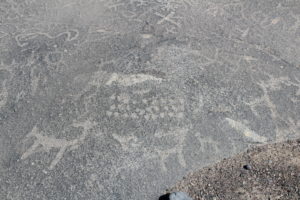
Sometime around 1000 AD, possibly earlier, people began leaving signs on the hillsides past which they travelled. These routes followed by historic people and their llama caravans are marked by geoglyphs created by moving surface stones on the red hillsides. The stones below, without a patina of ageing, are typically lighter in colour. Here we have geometric figures, groups of llamas, a giant shark, and more. But whereas the lines and images at Nazca are mostly drawn on a flat plain, looking up at the sky and difficult to see without airplanes and drones, the Atacama images look down on the valley pathways from the hills above.
Where the trading routes descend to the lowlands they are marked by cairns, apachetas, and casitas – little houses, like those roadside shrines with plastic flowers that commemorate the car crash deaths on the bends and drops of Peruvian roads. The highland peoples who still travel these roads, Quechua and Aymara, stop here to make offerings and ask the mother earth to look after their houses and their livestock.
Pica is half way from the coast to the mountains, and at least six travellers’ routes converge here. The 4000 metre high Coastal Cordillera, 60 km from the coast, cuts through the pampa or plains of Tamarugal and has a few wells and springs where underground water surfaces.
Pica, a midpoint on the route from coast to salt lakes, is a flash of dark green in the desert with a few thousand houses on Google Earth. At the eastern end of the town, hot springs feed the Municipal Baths – a natural pool formed in a fissure in the bedrock.
Six kilometres south east of Pica, at El Salto, there is a narrow rocky valley, and an amphitheatre of low cliffs where water trickles out to sustain a few bushes. Marked out on low sandy foothills are a series of rhomboids, some circles, and other geometric figures. There are rock paintings here too, faint figures on the cliffs, including a group of twelve llamas, with a man following behind.
Tracks lead out from the oasis of Pica east, inland and uphill to Salar de Huasco, a salt lake at 3800 metres. They go west towards the coast to Cerro Pintado, the painted hill, 38 kilometres away, two days journey for a llama caravan. They head north by north west, to Tarapaca, a town in a river valley, or southwards to the oasis of Calama.
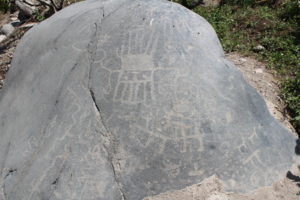
Fifteen km to the north west of Pica where one broad track contours a low hill, several hundreds of parallel paths can be seen in the sands. The paths display the characteristic extended roadway or fan of footpaths created by herds and flocks of animals crossing a flat landscape. They are known as rastrillo, or raked, pathways by Spanish-speaking archaeologists. In places the multiple tracks are a kilometre wide. The pathways approach a low rise and split, passing to either side of three giant drawings in the landscape, all pointing in the direction of the travellers. There are two great lizards, one fifty metres long (Pic 1)
To the west of the lizards, something like a three pointed crown has a 110 metre long pointer, on a bearing of 315 degrees, parallel to the two lizards’ axes to within a few degrees.
A little further west is a group of finely marked straight lines (20°22’19.45″ S 69°25’06.65″ W). The straight lines, which could have been directional pointers, have been walked across without compunction by the ancient travellers and their livestock. It suggests that the indicators served a purpose unknown to the later travellers, who nevertheless did understand, and perhaps create, the lizards, crowns and circles marked in the desert sands. There are layers of meaning here.
While the historic pathways over the hillsides largely avoid the geoglyphs, the crowns and the circles, the modern tracks left by four by four SUVs do not. One passes directly over a lizard.
The lines point roughly north west towards present day Pozo Almonte. The name, Almonte’s well, suggests it might have been an oasis in the desert. But the oldest building here dates to 1901, and the Municipal swimming pool is not fed by hot springs. This was a centre of the salitre or saltpetre trade, sending the first shipments of potassium and sodium nitrate fertilisers to Europe in 1820. Before the colonial presence, it could have been a stopover point on the route to the coast.
The lines may also have had have an astronomical purpose. 295 degrees would be the approximate bearing for summer solstice sunset in this part of Chile, and the lines look towards the coast.
To the south, the route to Calama will pass by more than 400 geoglyphs on the hills of Chug Chug, whilst to the west they reach Cerros Pintados, another major geoglyph site. Here the traveller coming from inland sees facing him a line of hills, part of the coastal mountain range. For a length of 3 km, the slopes of the hillsides are covered with over 400 figures.
Half of the designs are geometric – circles, rhomboids, ladders. One of the most common images is a pattern of rhomboids in a staircase pattern, recalling the Inca Chakana or stepped cross. The displays are primarily abstract, but they include birds, fish, quadrupeds, a shark, and a man on a raft. There are, too, figures with rayed heads, human and humanoid, mythic, godlike figures.
In 2005 a team of archaeologists examined sites along a 150 km route from the coast to the Pica oasis and beyond. The area studied was just a small part of the complete network, a web of routes covering over 400 km of coastline and highlands south to north.
For the archaeologists, Cerros Pintados represents a ritual change of the landscape from the highlands to the pampa, the plains. It offers a safe stopping point for travellers with water reserves, forage and sheltered space, both for those heading up into or down from the Andes, and those travelling north to south. It is the point of the innermost penetration of the Cordillera de la Costa, as a peninsula that penetrates the pampas.
From here you can sense the nearness of the sea: standing on the hills above the you feel a fresh and humid breeze very different from the salty and dry environment of the Pampas del Tamarugal and the salar that has been left behind. The branching “rake” trails suggest Cerros Pintados was a convergent centre for many routes linking points on the coast with the oases of Pica in the interior.
Two hundred metres east of the geoglyphs by the trails there are traces of water. Here too there are the remains of camp sites, with a fine view of the figures on the hillside. The camps included enclosures and fire places. The stone flakes and ceramics found there date to the late Horizon, 500 to 1000 years ago, the time of the Chimu and the Chincha in Peru. Lower, and older, are sea shells and ceramics, with organic material dated to 6000 years ago.
At a second campsite there was an apparently ceremonial pit with fish bones and maize together with parrot feathers. Another sealed underground pit was found with deposits of fish bones and corn cobs, pre-Inca ceramics, and preserved llama dung, and the corn cobs could be dated to 1000 AD.
The inland route continues to be marked by campsites with fireplaces, geoglyphs and occasional cemeteries or individual burials. The ceramics along the route show that it was used many peoples from diverse regions and groups. By the well of Santa Rosita, close to Pica, there is a looted cemetery, where excavations suggested a late pre-Inca date, perhaps 900 to 1400 AD.
In the winter of 2019 I visited Tacna, and walking out of town, the images were easy to see on the hillsides. Taking a taxi to a viewing point below a cluster of llamas and humanoids, I looked up at the hills and took some photographs. And then looked down at my feet. Where the parking area had cut through the slope, there was a thin stratum of debris – slivers of worked stone, possibly llama dung, and dry vegetation.
So up to 1000 years ago, travellers with llama caravans crossed the Atacama desert. They went from the coast to the highlands, and they also travelled parallel to the coast. They met and mixed with other peoples and marked their routes with big public signs. These signs are located at visible points, primarily small hills rising above the pampa, in a strip across the desert, midway between the coast and the highlands, over a distance of 500 kilometres. Meanwhile in Peru, we find many, perhaps most river valleys, the inland travel routes, marked by groups of engraved stones, petroglyphs, midway between the coast and the highlands, for 1500 kilometres from north to south. It has been proposed that they marked fertile and profitable coca growing areas, territorial boundaries. Perhaps, like the hillside images in the Atacama desert, they are marking not boundaries but meeting points. Rather than claiming possession of territory, they are offering to share, to trade – technologies, foods, skills. They are advertising boards, announcements, or just statements. We were here. Hello!
**************************************************************************************