There is a smell of fish and salt in the air in Chincha. It is only 5 km from the sea. Huancor, the site with the stone carvings, is 33 km from the coast in a direct line, just two days journey for a llama caravan.
Archaeological studies in the area show that the valley was inhabited during the four hundred years before the coming of the Inca by the Chincha Kingdom. Chincha means Jaguar, an animal of the Amazon forest. Chincha villages, cemeteries, and refuges have been found not only by the coast but through the upper valley territory too.
Broad swaths of the coast at this time were controlled by powerful, politically centralized groups. The Chincha kingdom would have flourished for five hundred years before the Inca influence reached them around 1475 AD. And the Incas never managed to dominate the Chincha. Inca structures at Huaca La Centinela, the coastal ritual centre, stand beside much larger Chincha buildings.
Only a few generations separated an independent Chincha from the Spanish invasion and the founding of Lima in 1535, and the earliest Spanish writers. Pedro Cieza de León’s La Crónica del Perú was published in Seville by 1553. Cieza describes the realm of the Chinchas as a “great province, esteemed in ancient times . . .splendid and grand . . . so famous throughout Peru as to be feared by many natives”. Their wealth and power was said to have supported major Chincha incursions into the highlands while the Incas were still consolidating the Cusco region.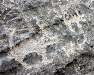
When the Inca forces began to move up the coast towards them, they gathered 30,000 fighting men, but the Tupac Inca offered peace. Subsequently the Incas resettled people from other regions in the vallley, and Inca nobles from Cuzco spent part of the year there, whilst the Chincha chiefs in turn spent some of their time in Cuzco.
The Chinchas had an abundance of gold and silver and their land was highly productive 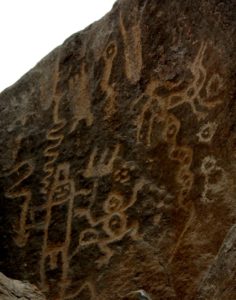 with a population of 25,000 persons when the Spanish conquered it. “ I doubt there are now five thousand, so many have been the hardships they have suffered…the diminishment of the people of this great valley is because of the long civil wars that were fought and the taking of them to serve as bearers…very few of the native llamas remain because in the civil wars they finished off most of the many that were here.”
Pedro Pizarro, a cousin of the leader of the invading Spanish forces, Francisco, provides firsthand observations of the Spanish encounters with the Inca beginning in the early sixteenth century. His Relación del Descubrimiento y Conquista de los Reinos del Perú (written nearly 30 years later in 1571) notes that the lord of the Chinchas was carried by litter in an honoured position in the Inca royal procession. According to Pedro Pizarro, in a subsequent conversation between the Spanish and the captured Inca Atahualpa, the Inca referred to the Chincha lord as a good friend and master of 100,000 sea-going craft. Francisco Pizarro claimed the lands of Chincha for himself, having heard of their productivity, and later passed them on to his brother Hermano.
Fray Cristóbal de Castro and Diego Ortega Morejón interviewed older inhabitants of 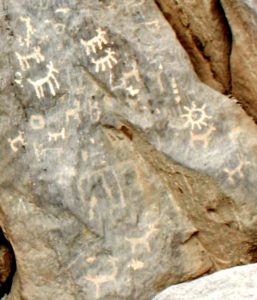 Chincha in a document referred to in shorthand as the “Relación” (1558), describing diplomacy and political maneuvering between the intact Chincha leadership and Inca representatives. From these accounts come a picture of Chincha as a centre of coastal economic power distinct from the north. It may have grown in power when the Incas subjugated the Chimu, another coastal trading power with a fleet of boats, about ten years before they turned their attentions to the south and central coast.
Part of the Chincha Kingdom’s political capital derived from access to a powerful and prestigious oracle called Chinchaycamac. ”Out of a rock came the voice of an oracle” according to Pedro Cieza. When the Incas finally did annex Chincha, it was more as allies than as subjects, and they continued to workship at Chinchaycamac as well as recognising 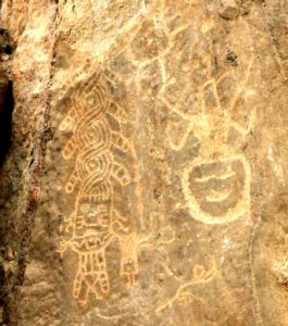 the Inca sun god.
Chincha is just 100 kilometres south of Mala so if the people of Mala had anything to buy or sell, they would be expected to be part of this trading network. There is copper within the Chincha territory – at Huancor, where a rocky hillside decorated with hundreds of petroglyphs surrounds an old, disused mine entrance marked with a curious human-shaped rock. There are also copper deposits in the hills between Mala and Chincha – more specifically, up the Mala valley at the level of Huancaini.
In 1970 a previously unknown Spanish document was found in a Madrid archive by Peruvian archaeologist Maria Rostworowski de Diez Canseco. The text has neither date nor author, but its title translates as “Notice (Aviso) about the rules under the Indian government during Inca times and how they shared the land and taxes” – commonly known now as the Aviso.
Maria Rostworowski proposed that it dated to the early 1570s and had been written by a Spanish clergyman stationed at the Dominican mission in Chincha. The “Aviso” describes the Chinchas as managers of a massive maritime trading operation stretching from Ecuador in the north to the south coast of Peru, trading copper from the southern Andes for Ecuadorian commodities—gold, timber, emeralds, and spondylus shell.
“with their sales and purchases they went to Cuzco and throughout the south, and others went to Quito and Puerto Viejo, from where they brought a great amount of Chaquiras of gold and beautiful emeralds and they sold them to the chiefs of Ica that were their good friends and closest neighbours. And so a lot of emeralds have been taken from the tombs of the dead chiefs of Ica.“
It presents a picture of a society or a kingdom which commanded the seafaring skills, boats, and trading networks that the Inca lacked, a coastal complement to their state controlled distribution network in the Sierra.
The evidence for the Chincha sea trade is limited. But rafts of balsa, grown in the tropical forests of Ecuador, were still being used off the coast of Peru into the nineteenth century.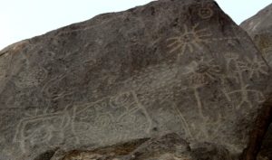
In 1526, a Spanish ship captained by Bartolome Ruiz venturing southward down the west coast of South America, captured a sea-going balsa raft off the coast of Ecador. A contemporary account says that it carried 20 men.
“The ship he took had a capacity of up to 30 toneles [25 metric tons]. The keel was made of canes as thick as posts bound together with ropes of what they call henequen, which is like hemp. The ship had masts of good wood and lateen-rigged sails of cotton, the same as our ships, and good rigging with henequen ropes. It carried stone weights like barber’s grinding stones as anchors.”
These rafts are thought to have been the vessels by which metal working reached Mexico from Ecuador in 800 CE, with further technological advances travelling from Chincha in 1200 CE. But there is no evidence that these cargo-carrying balso rafts reached so far south.
Information in the Aviso suggests the Chincha had separate communities of fishermen, farmers, artisans and traders, and a population of up to 100,000. This is much more than 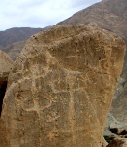 the 25,000 given by Pedro Cieza as the population when the Spanish annexed the territory, but by then the country had been ravaged by diseases introduced from Europe, killing up to 30% of the population at a time in successive waves of contagion.
The triple-mound complex of Centinela, Tambo de Mora, and La Cumbe may have been the seat of Chincha political power with the Chinchaycamac pilgrimage center at La Cumbe or at La Centinela itself. The site stands today five kilometres west of the centre of the present day town of Chincha Alta. There are three great mounds facing the river to the South and the sea less than 2 kilometres to the west, on the other side of the Panamerican highway.
La Centinela is the dominant great pyramid, thought to be the residence of the Chincha leaders. On the crumbling adobe walls at the top of the structure is a frieze moulded in high relief recalling the adobe moulding at Chan-Chan, the capital city of the Chimu, Peru’s other great coastal culture of the period. The crenellated diamond decorations resemble designs carved on the river-side rock at Lunahuana, 40 kilometres north. Inside the diamond there is a fish at Lunahuana, whereas here by the coast there is a spiral wave motif. Below is a sea bird, diving downward into the water. At Lunahuana, there are birds flying upwards to the mountain peaks.
Less than a kilometre from La Centinela, closer to the river and the sea, there is a pair of pyramids on either side of a split level central plaza at Tambo de Mora. And 200 metres to the north is La Cumbe, a pyramid 200 metres by 150 metres aligned parallel to the coast. This is thought to be the centre of the oracle, the Chinchaycamac, and may have its origins in the Paracas culture from 900 BCE. The surrounding areas housed textile workers, ceramicists and silver workers..
The old roads are still visible radiating out from La Centinela, running in straight lines to the east and south across the coastal plain. They would have transported goods and people to the Paracas valley to the south and toward the highlands of the Andes a week´s journey away. One points straight up the river valley of San Juan to Huancor.
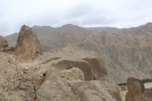
But the modern road from Chincha to Huancor heads first east into the sandy foothills and winds through a rocky dry valley, up and over a 800 metre pass before descending to the San Juan River valley. Seven kilometres further through broad green riverside fields we reach an outcropping wedge of hillside where a dry valley heads north.
“Bienvenidos” – welcome –“a los petroglifos de Huancor” says a green sign. “Cuidemos nuestro patrimonio cultural”. Care for our national heritage.
A path heads up from the road to skirt round the outcrop, and looking down on the path from slabs of stone slanting up the hillside to the right are several figures showing white against the dark brown stone. They hold high instruments longer than themselves, with bulbous ends.
Similar figures have been called flute players, and links have been proposed to a figure common in the rock art of South Western USA – where Arizona, Utah, New Mexico and Colorado meet. They are seen at several sites in Peru including Yonan, Miculla and Toro Muerto. They have been interpreted as people drinking, smoking, or inhaling hallucinogens.
By the path are some low grey boulders, displaying rayed heads with three dots in the centre, squares filled with dots, and two anthropomorphs with towering headdresses, plaited or twisted to several times the height of the figure, recalling the stylised design of the Raimondi Stela.
The path heads up past another sign reading “no destruyas los petroglifos de Huancor” and turns the corner into the dry valley. Above is a rocky promontory of tall rocks cleft with cracks, like a castle wall or a group of petrified guardians. Scrambling up I find a flat surface above these pillars of rock on the wedge of the hillside. Here there are smoothly 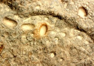 worked depressions like grinding bowls, as well as grooves and swirls all cut into the rock. There are cupules too, deep and broad on upper surfaces, or in horizontal lines of dots on the vertical face of boulders. Here we are looking down as if from a tower at the path below, the dusty plain towards the river, the valley extending on either side, and the grey mountains rising beyond. It feels like a centre point, with flat vertical rocks facing both West and South, facing towards the river and towards the dry valley.
Further up the latter there are more groups of stones, three or four flat vertical stones in an arc or looking down on a clear space, clustered with images. Behind one such group a higher rock bears the brightly cut name “Cesar”. Beyond is a rock with a rounded head like a human figure, apparently naturally worn. Its chest is decorated with figure of a man and two lines of four circles, and behind this rock are the collapsed remains of a mine entrance following a vein. Green copper ores are visible on small scattered stones around the shaft.
The rocks before the mine have a strong emphasis on circles filled with dots, or circles with inner circles, and dots filling the space between the two. There are seven such circles within dotted circles on a great boulder right by the entrance to the mine. It would be very easy to see these as symbolic mine entrances.
There are, as at Chincheros, many drawing of different apparent age. Some are faded to 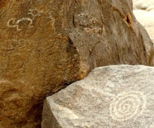 the same colour as the surrounding rock face, visible only because they have etched deep into the surface. Other images stand out bright against the dark background. There are drawings of different brightness and apparent age on the same rock, one superimposed on another.
The circle with dots, and the cupules, generally have the patina of the surrounding rock.
There are felines with a distinctive style reminiscent of those in the valley of Cañete, 55 kilometres to the north, which look fresh and new.
Heading back down, I am confronted by a man-jaguar head staring at me from a surface of rock at eye level close to the path. The face has opposing pairs of fanged teeth and U shaped eyes, features apparently related to the Chavin de Huantar iconography dated to 600 BC. It is shallowly drawn, with the light patina of a recent sketch, whilst the upper surface of the same rock has almost completely faded designs, evident only because they are shallowly cut into the upper surface of the rock. It seems remarkably similar to of the widely 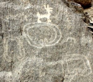 publicised Chavin style head of Palamenco, a petroglyph site further north. There are more convincing, though less complete, Chavin style images around Huancor.
As I was wandering amongst the stones an elderly man appeared walking up from a house down by the river, wearing a battered straw hat, sandals and a clean blue shirt. He approached politely and began to point out stones to me designs. “Look there…a llama… look at the snake…”
He farmed at the edge of the site and offered himself as a guide to the occasional visitors.
“What is your name?” I asked.
“Cesar”.
“Ah, I saw your name written on the rocks!”
He smiled modestly.
There are felines here in many forms and styles, and a quantity of long-tailed, sharp eared creatures, “fighting rats” according to Cesar. There are several man-lizards, climbing up the rock face, similar to those at Retama. There are pecking birds with dotted bodies, giant insects, leaping monkeys, fighting rats, a seven legged llama, seated figures in profile with flying hair, crosses, a frog, lines and crosses of dots, wagon wheels, squares and circles filled with dots, cupule dots within circles, and dots, lots of dots.
There seem to be many different phases of drawing here, and many different styles too. 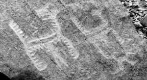 There are some remarkable feathered felines, highly stylised, in pairs. There is a grouping of frontal figures with flexible jointless rubber-man arms, the right arm pointing down, and the left arm raised above the head, waving at the visitors.
But the styles and images are largely different to those of Chincheros. There are no tumis, no tupus, few llamas – and no groups of llamas led by men. There are however a large 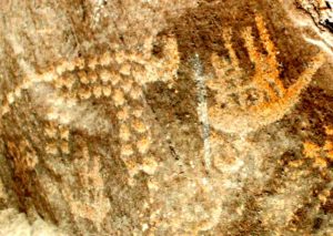 number of torcs or bracelets, like a piece of metal bent into a U, and the ends curved within. These resemble designs appearing on the hidden face of Pariacaca Rock, and nowhere else at Chincheros. There are also what could be heads with spiky hair, or just an outline with spiky hair, which again appears in three or four forms, high up on that hidden face.
One image however is quite outstanding. First because of its size – a giant image, almost a metre tall, high up on one of the most prominent rocks on the site: and secondly its subject, two people rowing a totora raft. Finely drawn, delicate and clear. There are other figures of rafts, much smaller, with one figure paddling. But these are small boats of reed for coastal fishing, not balsa cargo-carrying craft heading for Mexico.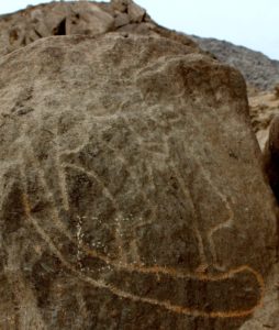
The markings on the stones at Huancor may of course date back to before the Chincha kingdom. The people themselves told Pedro Cieza that they had moved from elsewhere, and conquered the local peoples who were very short. Archaeology shows settled communities of the Paracas culture from 800 BCE, with influence from Nazca and from Wari. New arrivals in 900 AD lived by fishing and shell gathering, shortly followed by the Chincha. There may be contributions from all these periods. They certainly demonstrate a rich and complex history in the valley, with references to agriculture, fishing, mining, and more. But do they offer any insight into the engravings at Chincheros, 100 km to the north?