We can see a thousand years of history in a walk through modern day Lima. The present day zoo houses not only exotic animals but constructions spanning 1500 years. From the truncated pyramids of the Lima people and the adobe mounds of the Ychsma through to the late additions of the Inca. Then the Spanish built a house on top of one of the pyramids. There is nothing unique about the grounds of the zoo, because modern Lima is still dotted with such sites, although only a fraction remains of the rich civilisations that previously lived, worked and worshipped here.
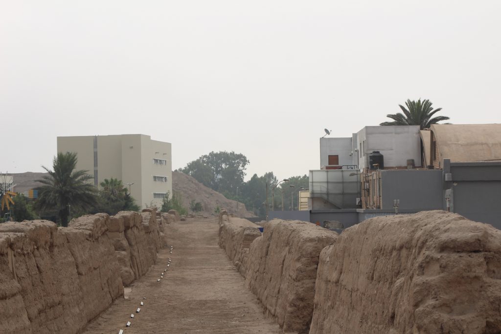
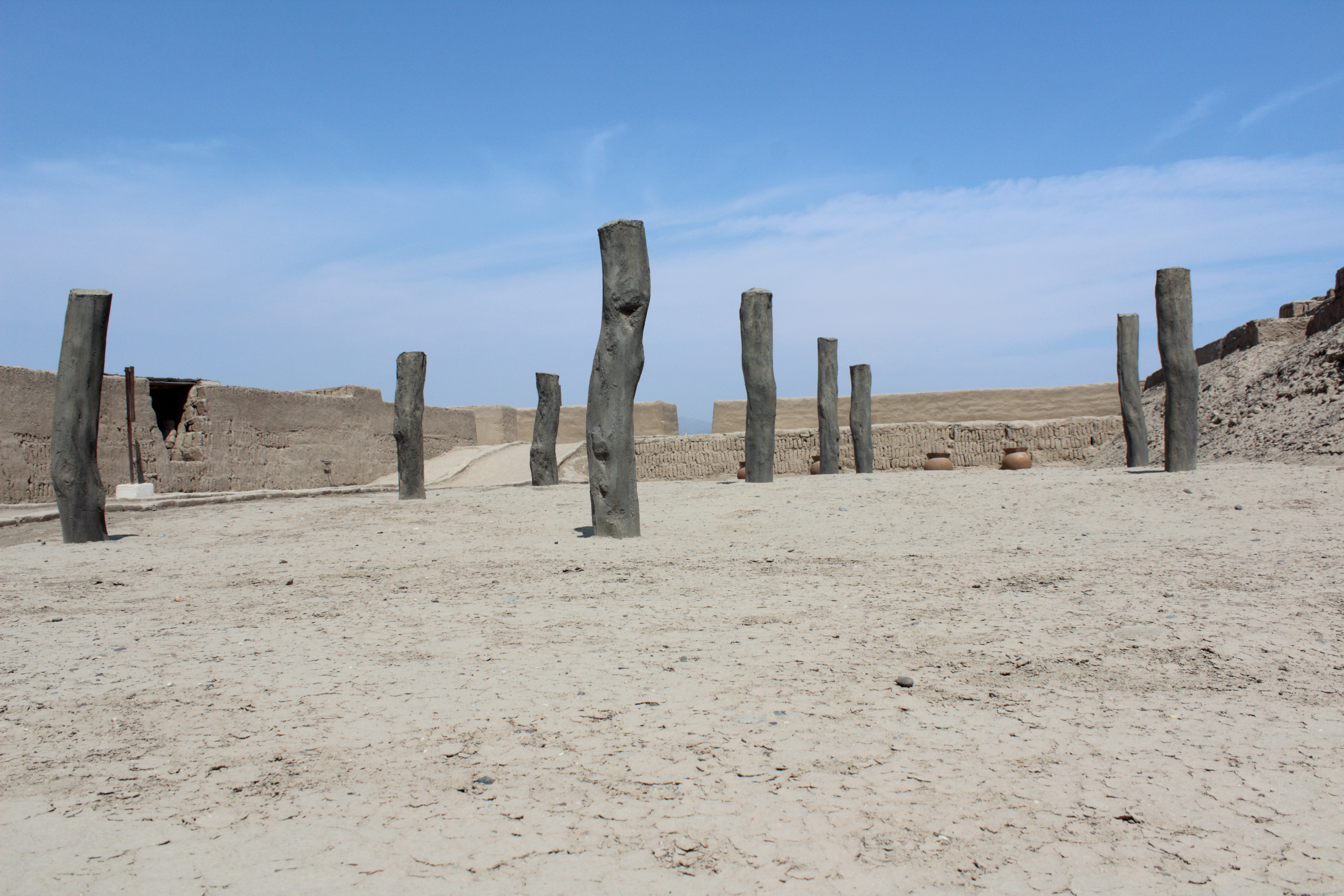
If we exit the zoo at Parque de Las Leyendas and walk round the high back end of the Huaca Tres Palos, where 98 posts were used, perhaps, to track the motions of the sun and stars, we can walk up a modern road that separates the grounds of the zoo from the grounds of Pontificia Universidad Catolica del Peru, more usually known simply as Catolica or PUCP. When we reach the eastern end of the huaca, we are at its front, the lower end where an access ramp leads to the storage and administrative structures on top. And leading towards this access ramp from the south is a fantastically preserved stretch of historic road, Inca or earlier, running through the university campus.
The road is six metres wide, with a smooth sandy surface, and high walls made of tapia adobe, large square blocks pressed in moulds in the Inca style. It stands a metre or two above the campus and the walls in places are a metre high. The road links the pyramids and huacas of Maranga, at the Zoo, with another complex of five flat topped mounds just a few kilometres away at Huaca Mateo Salado, so although its construction appears Inca, they probably refurbished an earlier Ychsma road between neighbouring settlements.
The University was founded in 1917 as a Catholic institution to defend against the liberal ideas, and even atheism, that it was thought were being promoted by the University of San Marcos. It acquired the land next to the present day zoo in 1944 and building commenced a few years later, but the road, which runs along high adobe walls similar to those which encircle the “Inca Quarter” of the zoo, remained as a divider of the campus, crossed only by a wooden bridge. In 2014 it was decided to integrate the road and wall into the campus with new bridges, informative displays, and night time lighting to highlight the adobe construction.
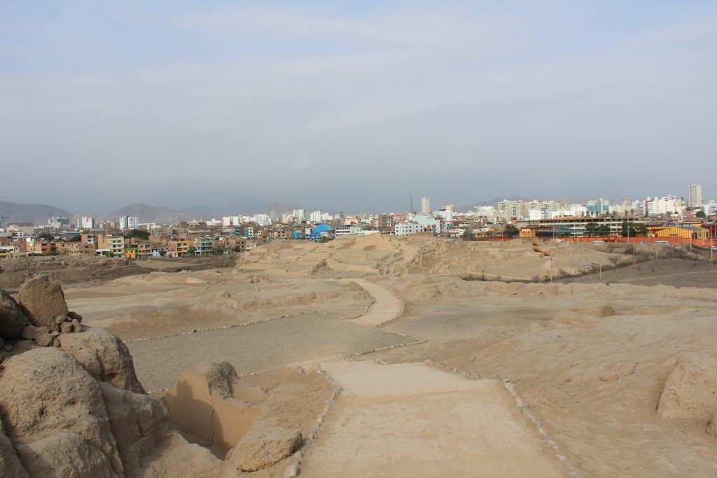
The wall and road comes to an end at a busy modern road which runs by the far side of the campus, but if we follow this road a block and turn south again, we can walk down the green central area of a dual carriageway aong a line of concrete paving slabs which cover a waterway, perhaps along the route of one of the irrigation canals. Alongside the canal are several small ruins or huacas, half concealed amongst the urban development, and then we approach a great roundabout, Plaza de la Bandera, and on the left there is a great open space dominated by not one but five truncated pyramids.
The area of protected land here is not as large as the zoo grounds but it is still impressive, more than twice the size of the zoo`s botanical gardens and boating lake combined. There are three large structures ahead, a smaller square mound besides the road, and the fifth tucked away amongst housing two hundred metres to the north-east.
The whole site is considered to be Ychsma, including ceremonial buildings, temples, and adminstrative and residential, or palaces. There are the recorded names of several chiefs of the area round present day Lima, who continued to occupy their positions as sub-chiefs under the Inca. They might have held sway over territories defined by the irrigation canals they controlled, and each of them may have had their own centre or group of pyramids. This collection of buildings then could be centre of the next chief south, or the next irrigation canal south of Maranga, two and a half kilometres away. There are signs of Inca presence here, building a new walled road, but not of the Wari. But if we take the second exit off the roundabout and head towards the coast, walking less than an hour, we will find them.
The National Museum of Anthropology is just eight blocks from here and worth a diversion. It holds the original Stela Raimondi and an excellent reproduction of the subterranean chamber housing the Lanzon, two powerful carved and incised stone monuments of the Chavin culture. Close by too is the Museo Larco, housed in an old colonial house built atop a pyramid mound. But our huaca trail takes us further south, past the Huaca Hallamarca, whose adobe bricks are not the classic libreria or bookshelf style, but a cruder rounded or conical shape, similar to grains of maize. The bricks appear to have been made by hand rather than with moulds – some bear the hand prints of their makers -and they are identified with a pre-Lima people who have been dated to 200 BE, before the current era. At least three more mounds in the city area use this construction.
The people here had ceramics, cotton textiles, and engraved gourds but not weapons. There are burials on the mounds from the Lima and Ychsma people, but also, confusingly, from Sican and Chancay to the north and Chincha to the south, encompassing 1500 years and nearly 1000 kilometres.
This huaca too was fed with water brought by canal from the Rimac, and today the same channel waters the Lima Golf Course, a private club in the heart of one of the most expensive areas of Lima. Investment banker Pedro Pablo Kuchynski, elected President in 2016, lives on Calle Choquehuanca, the street which runs passes the Huaca Hallamarca, just two blocks from the golf course. The polite armed policemen by the side of the road are not protecting the archaeological site.
The San Isidro district started to demolish the mound in 1941 but were stopped, and the Ministry of Public Works decided to remove it to make a public park in 1950, but it was finally reconstructed with more creativity than authenticity, with neat rectangular terraces and an imposing central ramp.
On the other side of the golf course, just one kilometre from the south west corner, we come to one of Lima`s most imposing visitor sites, the Huaca Pucclana.
The helicopter landing pad on the roof the Clinica Delgado, one of Lima`s most expensive clinics, offers a fantastic view. To the South, Parque Kennedy, and Avenida Larco leading down towards the upmarket Shopping Mall, (translation: US franchises and brand names including Converse sneakers, Hooters sports bar) LarcoMar , built into sea cliffs looking out over the Pacific and down on surfers riding the swell one hundred metres below.
To the west, you look towards the coastal road which runs by the pebble beach towards Lima`s port and twin city of Callao twelve kilometres west and the offshore island of El Fronton, traditionally used for political prisoners.
To the north west past Bembo’s fast food and the imposing Catholic Church on Ovalo Gutierrez are the tall trees of Lima Golf past which we have walked.
But below you to the north the rooftop looks down on a sprawl of walls, ramps and courtyards made of baked clay bricks at the side of a giant ramped pyramid, metres long.
For today`s visitors it is one of the glories of Lima. On the patio of an exclusive restaurant looking out over the ruins, parties of tourists from Japan, USA and Europe mix shoulders with Peruvian lawyers, mafia gangsters, members of congress and narcotraffickers.
The pyramid was built by the Lima people, fifteen hundred years ago, or 500 CE, Current Era, towards the end of the Lima cultural period. The mud bricks appear to have been made on site, perhaps as a form of tax or tribute, says the guide, which implies something imposed by a central authority, but perhaps too it was a voluntary contribution. At one side of the site are two small piles of mud baked hard by time and the sun, preserving the footsteps of those who were mixing the clay and water with their feet. One was clearly a child, the larger footprints are still tiny, to many visitors, but to the indigenous people of the andes, normal feet.
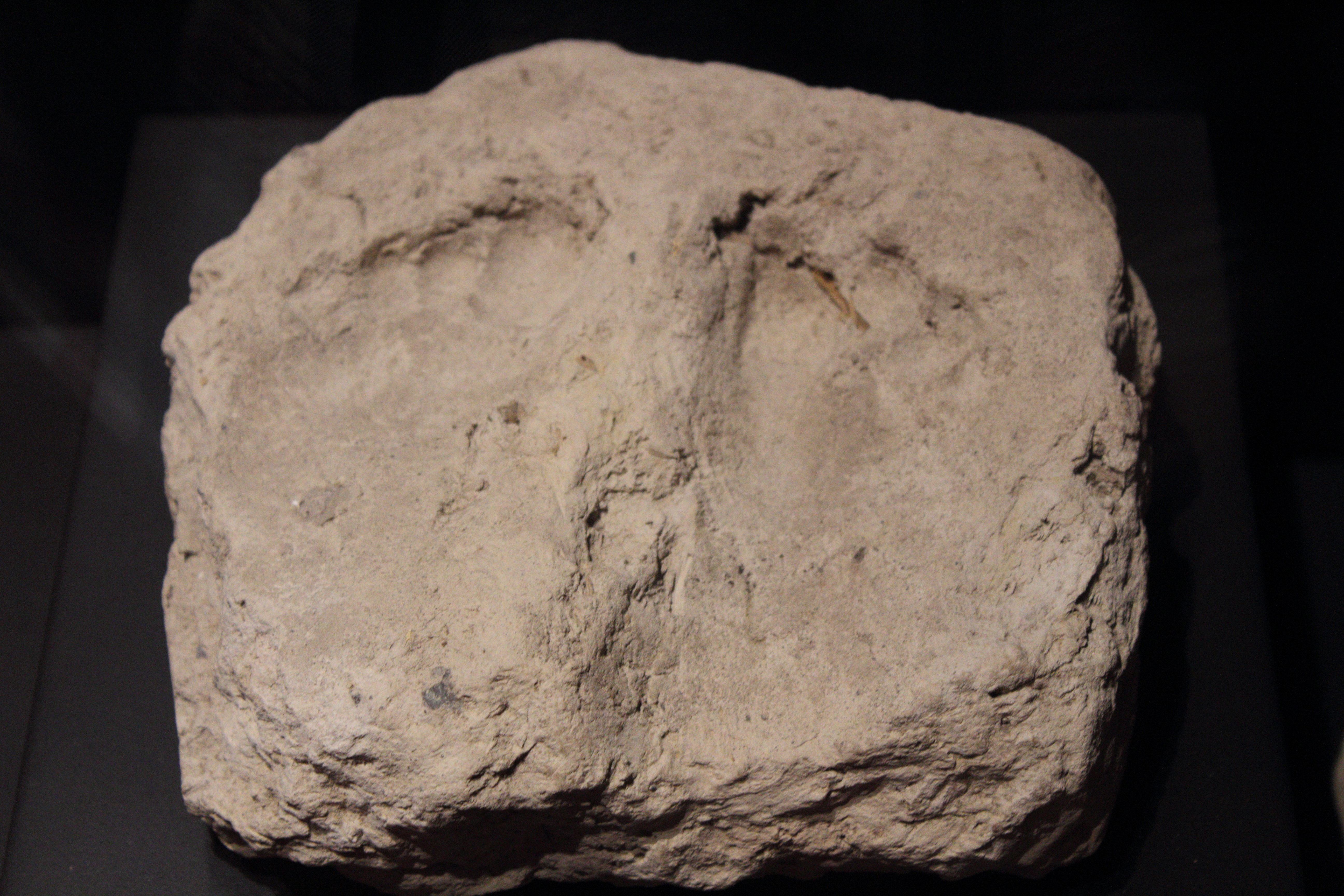
Tiny footprints in the adobitos, little bricks of sun -baked clay.
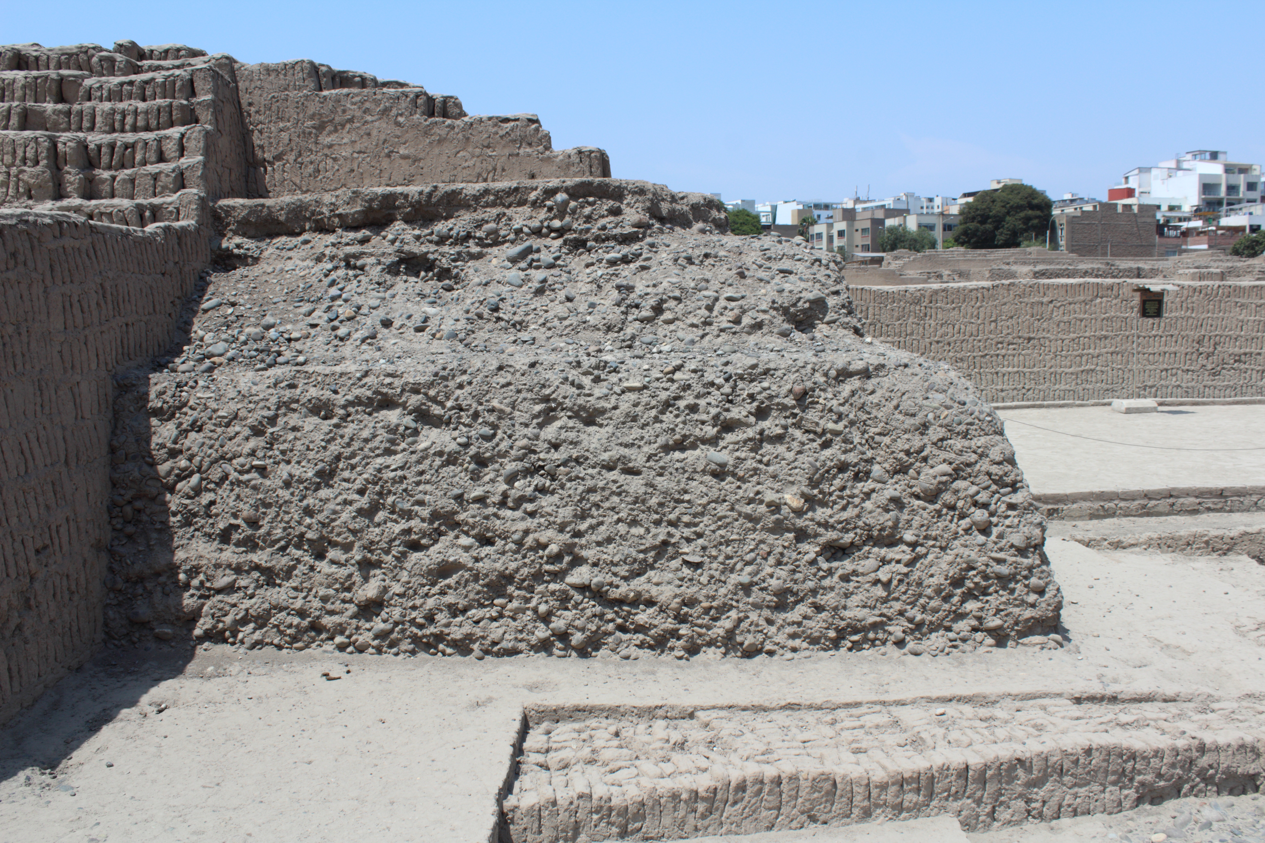
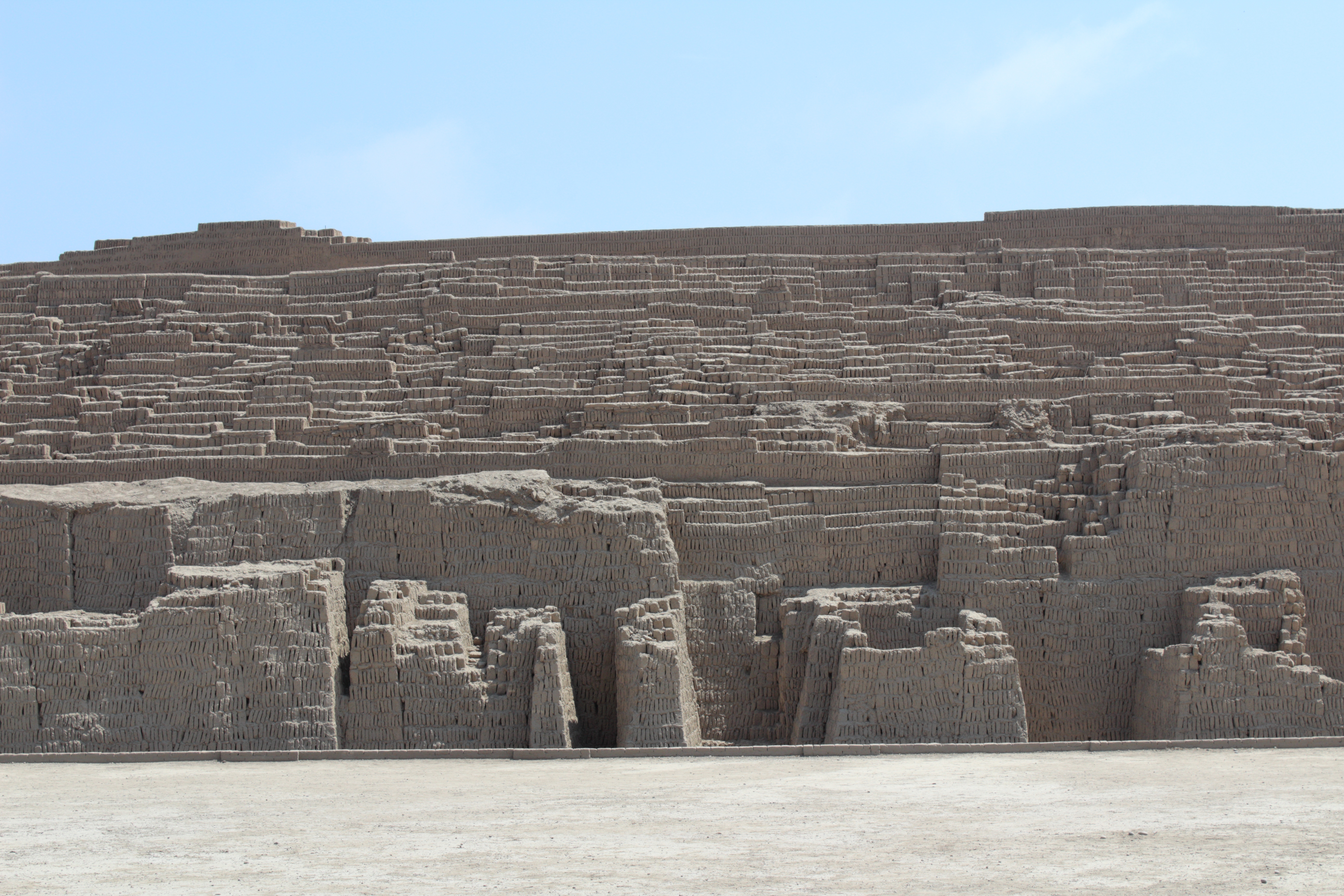
Tall walls at the front of the pyramid show the bookshelf construction, the libreria, very clearly. The “books” are in rows with spaces between them, each row topped and tailed with a mortar of clay. The rows are assembled one above the other in trapeziod or hexagon forms, and these larger blocks are then fitted together to build the wall. The appearance is spectacular and elegant. If it is true that different families were each asked to contribute a certain amount of adobes, perhaps one trapezoid, then the structure can be seen as a visual metaphor of how a group of people, a community or society, working together can raise themselves up to “god”.
Earlier phases of the building use cubic or unshaped blocks, as well as tapia, woven cane coated with a layer of adobe by hand.
The guided tour will show you how the structure grew over time, with walled rooms being infilled with gravel and stones after a ritual sacrifice: the smashing of a large ceramic pot with a design of a shark or sea lions, sometimes also the sacrifice of a young woman, and big dinners of sea food, particularly shark.
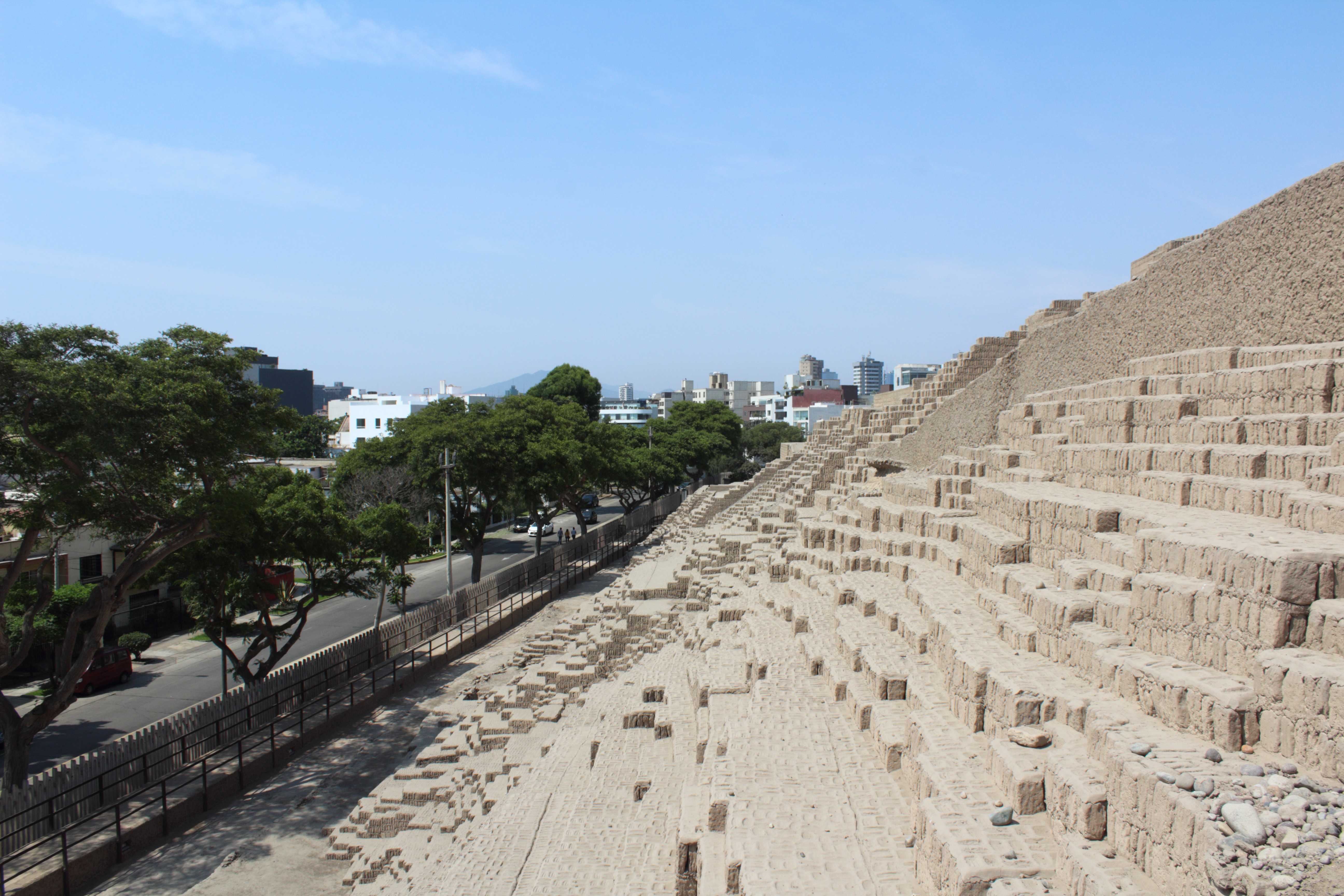
There were ramps to aid the construction which were later demolished, and the mound was completed as a series of terraces, ascending to a peak facing towards the sea less than two kilometres to the south-west.
There were plazas, patios and storage at the lower levels, constructed at different times, whilst the upper part of the platform was for ceremonial use for a privileged few.
The building was built on seven levels or platforms, and the guided tour takes you to the first three – the lowest levels damaged by brick makers who “mined” the pile of adobe up to the 1980s, the second level a fine patio surrounded by low bench walls for seating, the yellow paint still visible on the polished clay, with post holes perhaps to hold up a roof for shade, and hundreds of tiny holes in the floor where visitors places their offerings – the third is similar but smaller, and stairways or restricted passages lead from each level to the next, as a ritual progression. Something similar is evident in the temple of Chavin de Huantar, two thousand years earlier, and of course in the plaza and Church of St Peter in Rome, the pyramids of the Maya, and so on.
The sixth and seventh levels are still being excavated, and new burials are found every years. The burials are Wari.
At some stage in the second half of the first millenium CE, in 700 or 800 CE, there were social changes evident throughout the highlands and the central coast. They appear to relate to the expansion of the Wari people, centred in Ayacucho, and are evident in architecture, ceramics, textiles, iconography, ritual and above all burials.
Some time after the Lima people stopped using the huaca, the Wari came and used it as a burial site. Here and elsewhere around present day Lima they dug into now deserted pyramids to create their own tombs and bury their dead – high status burials, including fishermen, bureaucrats, weavers and priests, wrapped in fine cloths, with ceramics and food to accompany them.
The upper levels of the Huaca built by the Lima people with their plazas and rooms for feasting and offerings were used by the Wari as a ceremonial centre for high status burials.
The information on these Wari burials are still being analysed and much is unpublished, but a site further south, also arching across the Lima and Wari peoples to the Ychsma and finally the Inca, is Pachacamac.
One theory is that all these groups of huacas in the coastal plain of the river Rimac, in the present day city of Lima, these ceremonial and administrative mounds, were managed by chiefs who “served” the temple of Pachacamac. It is easy to see how such a model might appeal to those brought up in a Spanish colonial world where the catholic church, since the invasion, has similar hierarchical power structures.
What is clear is that Pachacamac had links to the north and inland, and that people came to the temple (and left behind their offerings, their textiles and their ceramics) from a great area of present day Peru, from the north and the south, the coast and the highlands.
The historic route to Pachacamac, at least for the Ychsma peoples in and a round present day Lima, was through the suburbs of Chorillos and Villa Salvador. To walk this twenty kilometres would not only take most of the day, but lead us through districts which are undoubtedly dirty and neglected, and if the popular press can be trusted, are highly dangerous, bullet riddled and delinquent. Half a million people live there.
…Back to 42 – A trip to the Zoo…
…Forward to 44 – Pilgrimage to Pachacamac – unfinished…
…Forward to 45 – Cardal and Pan…